Main Page
About Me
Research
Links
Contacts
| Introduction | Regime Properties | IR-Only Regimes | Statistical Model | GCM Evaluation | Precipitation Changes | References |
|---|
Introduction
This page contains past and ongoing work on tropical convection. Using cloud regimes (see below) as proxies for convection on the large-scale, I investigated the large-scale properties of convection by compositing the regimes with various large-scale variables. These composites are used to drive a three-hour field of convection through statistical modelling to investigate the organisation of convection. The results allow us to address deficiencies in global-scale climate models associated with convection.
For more information on these studies, please click on the respective links at the top of this page.
For my research interests, please click here.
ISCCP Regimes
 |
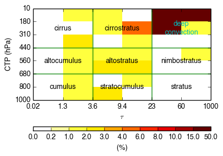
| Figure 1: An example of a ISCCP D1 joint-histogram. |
As clouds are the fingerprints of convection, we can infer information on the convective state of the environment by observing the cloud fields. In my study, the cloud data product I am using is derived from measurements by a network of satellites under the International Satellite Cloud Climatology Project (ISCCP; Schiffer and Rossow, 1983). The ISCCP D1 dataset (Rossow and Schiffer, 1999) divides the globe up into equal-area grids of 280 km × 280 km resolution and profiles the statistical distribution of clouds in each grid at three-hour intervals using a joint-histogram of cloud top pressure and optical thickness. An example of such a joint-histogram and its associated cloud morphology is shown in Figure 1 to the right.
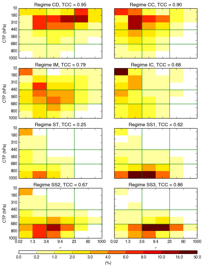
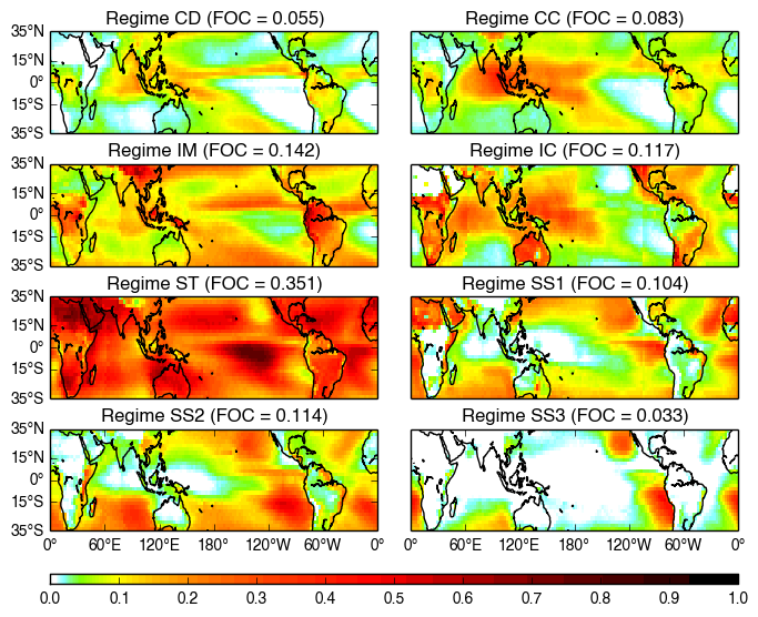
By applying a cluster analysis, Jakob and Tselioudis (2003) derived an objective method to classify these joint-histograms. In my study, I use these cloud regimes as proxies for convection. Between 35°N and 35°S where I am focussing on, there are eight cloud regimes, each giving an indication of the convective state of the environment. Figure 2 below shows the joint-histograms representing centroid (mean of all members) for each cloud regime. The regime at the top-left, labelled CD (for Convective regime dominated by Deep stratiform clouds) indicates an envionment where there is intense deep convection with high levels of organisation. Its high incidence of deep stratiform clouds suggest that it is associated with large convectie systems. The regime labelled CC (for Convective regime dominated by Cirrus clouds) is an environment where there is deep convection but more isolated, a fact betrayed by the higher occurrence of cirrus clouds. Regime IM (for Intermediate regime with a Mixture of clouds) describes an environment which is highly varied but with some deep convective clouds and some mid-level clouds. This most likely indicates an environment with isolated deep convection (e.g. isolated thunderstorms) and some cumulus congestus clouds (which are often recognised as the predecessor of cumulonimbus clouds). These three regimes represent the dominant building blocks of convection in the tropical atmosphere, thereby allowing us to analyse the properties and organisation of convection on the large-scale.
Additional information on the cloud regimes are available on Christian Jakob's website and on the ISCCP webpage: tropics (6 regimes) and extended tropics (8 regimes). Details on this work can be found in Jakob and Tselioudis (2003) and Rossow et al. (2005).
Details
 |
| Figure 2: The centroid for each cloud regime, together with the regime name, total cloud cover and frequency of occurrence. |
 |
| Figure 3: The geographical distribution of each cloud regime. |
| Regime | Convection type |
|---|---|
| CD | highly-organised deep convection |
| CC | less-organised deep convection |
| IM | isolated deep convection |
| IC | remnants of deep convection (?) |
| S* | convectively-suppresed |