Paul R. Houser, NASA/GSFC Hydrological Sciences

Paul R. Houser, Page 27 7-Jun-01
Resolution: 1/8 degree; continental U.S; <1 hour time step;
near real time & retrospective.
Models: Mosaic, VIC, NOAH, Sacramento, CLM, Catchment, TOPLATS, Bucket.
Assimilation: Surface
temperature, snow, soil moisture.
Forcing: Eta
model and observed Stage-4/gage precipitation, GOES insolation (NCEP).
Timing: real-time,
short-term retrospective, long-term retrospective.
•Real-Time (NCEP): LDAS results and forecasts available within 24 hours of
real-time
•Short-Term Retrospective (GSFC): Identical to
real-time for modern forcing (1996-present)
•Long-Term Retrospective (UW-P): 50+ years using reduced resolution and best available
forcing.
Parameters:
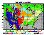
•Vegetation: UMD classification, parameter mapping (GSFC).
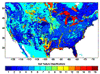
•Soil: Soil Maps and Parameters (OH).
•Topography: Digital Elevation Models (GSFC).
North American Land Data Assimilation System
GSFC,
NCEP, Princeton, U. WA, Rutgers, U. MD, U. AZ, etc.
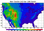
Topography (GSFC)
Vegetation (GSFC)
Soils (NWS-OH)