
PLMR+ - Polarimetric L-band Multibeam Radiometer & Thermal Imager
A new airborne facility for environmental, hydrological, atmospheric and oceanic research providing high resolution measurement of soil moisture, temperature and salinity
A new national facility,
for airborne remote sensing of key environmental variables is currently being
developed through the support of the Australian Research Council,
The new instruments enable high-resolution mapping of near-surface soil moisture, land surface salinity and temperature, and ocean surface salinity and temperature, providing unprecedented detail on characteristics critical to our understanding and management of the environment. The small instrument size and weight enables use of a light aircraft as the observing platform, providing the national (and international) research community with an affordable tool, hitherto unavailable.
The facility includes:
o A dual polarisation L-band (1.4GHz) passive microwave radiometer, and
o A thermal imager.
These instruments enable the measurement of top 5cm soil moisture content and salinity under low to moderate vegetation conditions and/or ocean salinity at 50m resolution, and surface temperature at 1m resolution (approx 300m swath width at 150m flying height) using a low-cost light aircraft as the platform. The dual polarisation microwave measurements enable simultaneous solution of soil and vegetation moisture content while soil temperature is estimated from the thermal data. The high resolution thermal data will allow the development of soil moisture downscaling algorithms from spatially averaged data at a ground resolution that can be adequately monitored using ground-based techniques.
Over water, the microwave measurements are a function of ocean salinity and temperature. In this case, the high resolution thermal data will allow simultaneous mapping of ocean salinity and sea surface temperature on the same platform, and the dual polarisation data will allow more accurate extraction of ocean salinity.
The thermal data may also be used to estimate evapotranspiration directly.
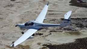 The
platform on which these instruments are flown is a Small Environmental Research
Aircraft (SERA), a Diamond Dimona MPX. There are also a range of other
instruments available to be carried by the aircraft, allowing measurement of
vegetation indices, meteorological parameters, evapotranspiration, ground
surface elevation and vegetation height. The capability to measure such a
comprehensive range of remotely sensed parameters from a single low-cost
airborne platform is unique worldwide. Moreover, the high resolution dual
polarisation microwave data afforded by this airborne instrument is
unprecedented.
The
platform on which these instruments are flown is a Small Environmental Research
Aircraft (SERA), a Diamond Dimona MPX. There are also a range of other
instruments available to be carried by the aircraft, allowing measurement of
vegetation indices, meteorological parameters, evapotranspiration, ground
surface elevation and vegetation height. The capability to measure such a
comprehensive range of remotely sensed parameters from a single low-cost
airborne platform is unique worldwide. Moreover, the high resolution dual
polarisation microwave data afforded by this airborne instrument is
unprecedented.
The thermal imager is presently being tested and the PLMR is due for delivery in November 2004 with test flights presently scheduled for early 2005. We expect the facility to be available for general use from mid 2005.
For further information and fee schedule, please contact Dr Jeffrey Walker. Additionally, download this poster.